| Index |
Previous |
Next |
AspEdit manual Countries
Purpose
AspEdit can use country files for the following:- Displaying country borders on the map,
- Insertion of border segments in shapes,
- Use countries in the add / subtract shapes function.
Data source
The borders and coastlines offered with the AspEdit package are data based on GSHHG and WDBII See www.ngdc.noaa.gov/mgg/shorelinesGSHHG is distributed under the GNU Lesser General Public License (LGPL) version 3 or later
The acknowledgement must not be be removed from the files.
Country file location
Country files must be located in the "borders" folder in the AspEdit root folder.Country file format
You can create / edit the country files as desired. Adhere to the following rules:- Every country is contained in a single file.
- The files must be located in the "Borders" folder.
- The shapes must be closed. This means that the shape must be a full loop, the end point must be identical to the first point.
- For correct functioning, the files must be clockwise. This means that, viewed from the center of the country, the points must loop clockwise.
- A file can contain a single shape only. Islands or big lakes must be placed in separate files.
- The format is simple latitude & longitude in text format.
- The coordinates' format is permissive, see coordinates. The latitude and longitude must be separated by a blank or a tab.
- Every coordinate must be placed on a single line.
- Comment lines must start with #
Resolution
Exported OpenAir files use the points in the border files. Too high resolution will result in an excessive number of points in the OpenAir files, too low resolution will result in too coarse definition. The resolution in the files delivered in the package are a good compromise. They are based on the "h" files of GSHHG and WDBII data sets.Common borders with 3 or more countries.
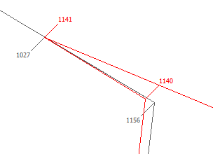
It is important that the borders between countries consist of common points.The example in the drawing below will cause problems: point 1156 (of country A) doesn't match with point 1140 (of country B). The add / subtract shapes function will not work:
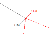
The image below shows how it should be:
You can use the AspEdit country editing functions to adjust common points.
Editing countries from AspEdit
In the combo-box at the top of the list, select "Countries".double click on the country to be edited, the Country dialog box will open.